
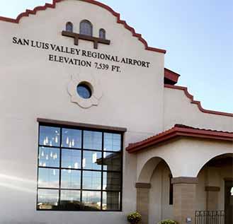
SLV Regional Airport (KALS)
The San Luis Valley Regional Airport is located in Alamosa and serves the entire San Luis Valley. The new airport terminal was completed in 2015.
Denver Air Connection is the provider of essential air service and flying as a United Airlines carrier. They offer daily flights to and from Denver, Colorado. Reservations can be made online here.
Ph. (719) 589-1138
2490 State Avenue
Alamosa, Colorado 81101
CONTACT US
#FFFFFF

#FFFFFF
Airport Manager
Will Hickman
/sites/alamosacounty/files/styles/max_1920/public/img_0252_sm_1_1.jpg
#FFFFFF

#FFFFFF
#FFFFFF
| FBO: | (719) 587-5332 |
| Depot Avionics: | (719) 589-6777 |
| FAA Identifier: | KALS |
| Lat/Long: | 37-26-05.7000N / 105-51-59.6000W |
| 37-26.095000N / 105-51.993333W | |
| 37.4349167 / -105.8665556 (estimated) | |
| Elevation: | 7539 ft. / 2297.9 m (surveyed) |
| Variation: | 09E (2010) |
| From city: | 2 miles S of ALAMOSA, CO |
| Time zone: | UTC -7 (UTC -6 during Daylight Saving Time) |
| Zip code: | 81101 |
| Airport use: | Open to the public |
| Activation date: | 03/1941 |
| Sectional chart: | DENVER |
| Control tower: | no |
| ARTCC: | DENVER CENTER |
| FSS: | DENVER FLIGHT SERVICE STATION |
| NOTAMs facility: | ALS (NOTAM-D service available) |
| Attendance: | DAYLIGHT HOURS |
| Wind indicator: | lighted |
| Segmented circle: | yes |
| Lights: | DUSK-DAWN ACTVT HIRL RY 02/20, MALSR RY 02, PAPI RY 02, REIL RY 20, AND VASI RY 20 - CTAF. |
| Beacon: | white-green (lighted land airport) |
| Fire and rescue: | ARFF index A, Alamosa Fire Department |
| CTAF/UNICOM: | 122.8 |
| WX ASOS: | 135.175 (719-589-5669) |
APCH/DEP SERVICE PRVDD BY DENVER ARTCC ON FREQS 128.375/379.95 (ALAMOSA RCAG).
| VORradial/distance: | ALSr322/5.7 |
| VOR name: | ALAMOSA VORTAC |
| Freq: | 113.90 |
| Var: | 13E |
| Fuel available: | 100LL JET-A |
| Parking: | hangars and tiedowns |
| Airframe service: | On Call |
| Powerplant service: | On Call |
| Avionics: | YES |
| Bottled oxygen: | HIGH/LOW |
| Bulk oxygen: | NONE |
| GPU: | Yes |
Runway 2/20
- Dimensions: 8519 x 100 ft. / 2597 x 30 m
- Surface: asphalt/grooved, in good condition
- Weight bearing capacity
- Single wheel: 52.0
- Double wheel: 70.0
- Runway edge lights: high intensity
| Runway 2 | Runway 20 | |
|---|---|---|
| Latitude: | 37-25.510990N | 37-26.703985N |
| Longitude: | 105-52.535780W | 05-51.609288W |
| Elevation: | 7539.2 ft. | 7539.1 ft. |
| Gradient: | 0.1% | 0.1% |
| Traffic pattern: | left | left |
| Runway heading: | 023 magnetic, 032 true | 203 magnetic, 212 true |
| Declared distances: | TORA:8519 TODA:8519 ASDA:8519 LDA:8519 | TORA:8519 TODA:8519 ASDA:8519 LDA:8519 |
| Markings: | precision, in fair condition | precision, in fair condition |
| Visual slope indicator: | 4-light PAPI on left (3.00 degrees glide path) | 4-box VASI on left (3.00 degrees glide path) |
| Approach lights: | MALSR: 1,400 foot medium intensity approach lighting system with runway alignment indicator lights | |
| Runway end identifier lights: | yes | |
| Touchdown point: | yes, no lights | yes, no lights |
| Instrument approach: | ILS | |
| Obstructions: | none | 36 ft. tree, 1800 ft. from runway, 400 ft. right of centerline, 44:1 slope to clear |
| Ownership | Owner | Manager |
|---|---|---|
| Publicly-owned | City and County of Alamosa | Will Hickman |
| 8900-A Independence Way | 2490 State Ave | |
| Alamosa, CO 81101 | Alamosa, CO 81101 | |
| Phone (719) 589-4848 | Phone (719) 587-5211 |
| Aircraft based on the field: | 45 |
| Jet aircraft: | 3 |
| Single engine airplanes: | 32 |
| Multi engine airplanes: | 9 |
| Helicopters: | 1 |
| Aircraft operations: | avg 84/day* |
| transient general aviation: | 47% |
| local general aviation: | 26% |
| air taxi: | 23% |
| military: | 3% |
*for a 12-month period ending 31 May 2009
- 893 FT PAVED BLASTPAD RY 20.